The Global Impact of Open Data
Kennedy vs. the City of Zanesville, United States
Open Data as evidence
by Christina Rogawski, Stefaan Verhulst and Andrew Young*
For decades, residents of the Coal Run neighborhood in Zanesville Ohio, a predominately African-American neighborhood, were denied public water service despite living within one mile of public water lines.2 The situation went back to 1956, when a now-defunct water board refused to extend service to parts of Coal Run. As some residents described in a 2008 New York Times article, the water stopped “where the black folks started.”3
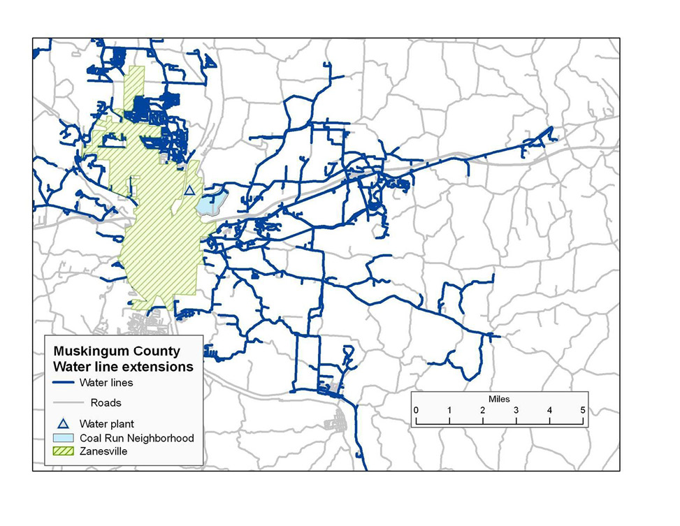
Figure 1: Map of Water Line Extensions in Muskingum County4
Many residents were forced to rely on extreme measures to source water. For example, they had to use electric pumps to retrieve water from a cistern that was fouled with animals and residue from old coal deposits. Due to contamination, many residents couldn’t even use the water and spent time and money instead trucking water in.5 Others collected rain via buckets and gathered snow in the winter.6
Not only did the situation impose a daily burden on residents, it was also demeaning and humiliating. One lawyer cited the following example, which reveals the racial disparities in water distribution:
“One man … spent the whole morning trying to get water or deal with the water shortage. Meanwhile, he could see his white neighbor caddy corner to him sprinkling his lawn. It became clear if you were white and living outside Zanesville you would get water, but if you were black, you wouldn’t.”7
In 2002, some two dozen black residents of Coal Run filed a complaint with the Ohio Civil Rights Commission, saying they had been denied service because of race. The next year, the commission found “probable cause” of discrimination and a month after that, Muskingum County officials announced they would extend water to Coal Run, to be completed in 2004.8
The decision to extend the water lines did not mark the end of the battle, however. In 2005, after construction on the new water lines was completed, 67 residents of the Coal Run neighborhood filed a lawsuit, alleging that the City of Zanesville and the East Muskingum Water Authority had refused to provide them public water service for over 50 years simply because they lived in the one predominately African-American neighborhood in a virtually all-white county9 – in the 2000 Census, Muskingum County was found to have a 93.9 percent white population, with the black community making up only 4 percent of the county.10
The case was eventually taken up by the civil rights law firm Relman, Dane & Colfax, based in Washington, D.C. In 2008, after a three-year trial, a federal jury returned verdicts totaling nearly $11 million against the City of Zanesville. This case study examines the innovative use of public data that went into building the successful case and, in the process, addressing a decades-old civil rights violation.
Read MoreTo determine whether there was an association between race and access to public water services in the Coal Run neighborhood, the plaintiff’s lead attorneys, John Relman and Reed Colfax, obtained the demography services of Dr. Allan Parnell of the Cedar Grove Institute for Sustainable Communities. The Cedar Grove Institute is a nonprofit in Mebane, North Carolina that provides technical assistance, analysis and training to help community groups promote equitable community development.11 It grew out of the for-profit company, McMillan and Moss Research, Inc., whose “research and analyses were being called for in cases involving civil rights, predatory lending, segregation in schools, institutionalized discrimination and community economic development.”12 Mr. Colfax reached out to Dr. Parnell based on the recommendation of Jennifer Klar, now a partner at Relman, Dane & Colfax who met Dr. Parnell during a conference, and based on the Cedar Grove Institute’s reputation for work in civil rights cases and community development. Ms. Klar, as well as pro bono attorneys from the law firm Jones Day and other organizations, also worked with Mr. Relman and Mr. Colfax on the case.13
As civil rights attorneys, Relman and Colfax were well aware of how public data can help provide critical evidence in cases, but lacked the technical know-how to analyze the data themselves. Parnell, a well-known public data specialist, regularly serves as an expert witness in civil rights cases using open data. For example, he was one of the plaintiff experts in Texas Department of Housing and Community Affairs v. Inclusive Communities Project, the 2015 Supreme Court decision that affirmed the validity of disparate impact cases where public data are key.14 Parnell therefore led the data research and analysis for Relman and Colfax, eventually settling on a strategy of combining data from multiple sources (public GIS data, water billing data and demographic data) to create maps that established a clear pattern of racial discrimination.15,16
Relman and Colfax agreed with Parnell’s strategy in using public data. Once the decision was taken, however, Parnell soon realized that census data would not be effective due to the small size of the neighborhood in question and the distribution of residents within the blocks. For example, within each block, the northern part was typically predominantly white and the southern predominantly non-white.
Instead of using census data, Parnell proposed using publicly available geographic information systems (GIS) data from Muskingum County to perform a house-by-house analysis within the neighborhood.17 Although not available via an open data portal, GIS data is typically available by request, and Parnell and Reed successfully obtained the needed GIS data through a direct request to Muskingum County officials, and it was provided in a standard, machine-readable format. GIS data uses spatio-temporal location as the key index variable. Parnell explained that for most municipalities, one needs to first fill out a form requesting access to such GIS data, but that there is a “wealth of data available if you know how or where to ask for it.”18 Essentially, the nature of GIS data allows users to analyze and interpret data in ways that make it easier to identify, manipulate and understand relationships, patterns and trends, and then visualize that data in forms that are accessible for anyone (data expert or not) to understand and share (e.g., maps, globes, reports and charts.)19 Parnell, being experienced with GIS data, recognizes the opportunities GIS data presents more readily than those with less experience, such as attorneys. However, should the open data movement continue to grow, more people of all backgrounds could recognize and use GIS data.
Parcel data – which identified all occupied houses in the study areas, the location of water lines with dates of construction, Zanesville’s city limits and the street locations – provided the backbone of the case. Additionally, Relman, Dane & Colfax obtained water-billing data, which provided the addresses of all houses with public water service. With this data in hand, Parnell’s team of paralegals undertook a door-to-door effort to: a) confirm that property identified in the parcel data was an occupied house; and b) determine racial composition and how long each resident had lived in that location in order to determine that “there was no difference between the people with and without water other than race.”20
“The easier it is to access data, and the more people that can access data without having to pay for it, the more egalitarian society we will have.”
Using the public GIS data, the household survey information, the plaintiff information and the addresses of houses with billed water service, Parnell’s colleague, Ben Marsh, Ph.D., Professor of Geography and Environmental Studies at Bucknell University, built the GIS layers for the maps showing a clear pattern of racial discrimination. Parnell wrote the expert report used in the case based on the maps, survey information and additional information taken from the plaintiffs. During the trial, Relman and Colfax walked the jury through the information contained in the maps by rebuilding Parnell’s maps, “layer by layer,” while explaining how each piece of information was obtained and what it uncovered about water access discrimination.21
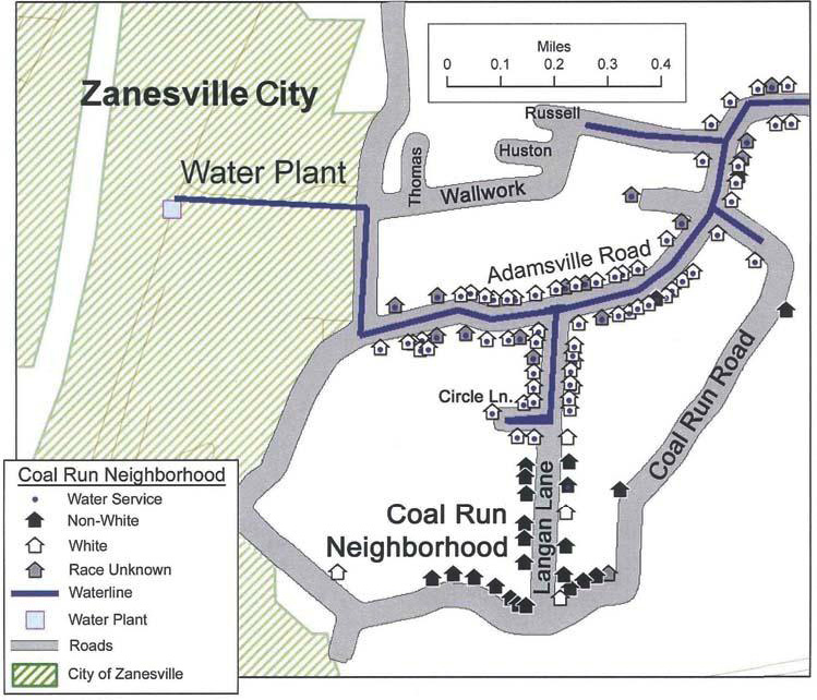
Figure 2: Map of Water Line Extensions in Muskingum County with GIS layers22
Meanwhile, the expert testifying on behalf of the defense attorneys representing the City of Zanesville, Muskingum County and the East Muskingum Water Authority also attempted to use data-driven maps to support the opposition’s case. The defense’s expert, however, did not effectively manipulate the data or maps, leading to a mismatch between the claims made by the attorneys and the information being displayed. The defense used the GIS and census data to try and argue that race did not affect who had water service, claiming that all residents of a certain census block had water if a water line intersected any part of that census block. This is demonstrably false, and the defense was unable to prove the claim. Parnell countered the assertion using the same census data, showing that in 2000, the water lines for the block in question only served 34 African-American residents – all of whom lived in a nursing home whose population was 88 percent white.23
The use of open data, in some cases drawn from the same source, to make contradictory points from two sides of the same court case demonstrates the danger of selective, perhaps manipulative use of data to lead people to make incorrect conclusions. The defense was unable to use the data to create a compelling case, however, and, as a result, appeared “clueless.”24
Read MoreReference
2 "Kennedy v. City of Zanesville." Relman, Dane & Colfax PLLC. http://www.relmanlaw.com/civil-rights-litigation/cases/zanesville.php
3 Johnson, Dirk. "For a Recently Plumbed Neighborhood, Validation in a Verdict." The New York Times, August 11, 2008. http://www.nytimes.com/2008/08/12/us/12ohio.html?_r=0.
4 Parnell, Allan M. “Maps Used in Support of the Plaintiff’s Argument in Kennedy et al. v. City of Zanesville, et al.” Legal Services of Northern California Race Equity Project. August 6, 2008. http://equity.lsnc.net/2008/08/maps-used-in-support-of-the-plaintiff%E2%80%99s-arguement-in-kennedy-et-al-v-city-of-zanesville-et-al/
5 GovLab interview with Tara Ramchandani, Attorney, Relman, Dane, & Colfax PLLC, August 3, 2015.
6 Johnson, Dirk. "For a Recently Plumbed Neighborhood, Validation in a Verdict." The New York Times, August 11, 2008. http://www.nytimes.com/2008/08/12/us/12ohio.html?_r=0.
7 GovLab interview with Tara Ramchandani, Attorney, Relman, Dane, & Colfax PLLC, August 3, 2015.
8 Johnson, Dirk. "For a Recently Plumbed Neighborhood, Validation in a Verdict." The New York Times, August 11, 2008. http://www.nytimes.com/2008/08/12/us/12ohio.html?_r=0.
9 "Kennedy v. City of Zanesville." Relman, Dane & Colfax PLLC. http://www.relmanlaw.com/civil-rights-litigation/cases/zanesville.php
13 GovLab interview with Allan Parnell, Ph.D., Vice President, Cedar Grove Institute for Sustainable Communities, October 2, 2015.
14 GovLab interview with Allan Parnell, Ph.D., Vice President, Cedar Grove Institute for Sustainable Communities, July 21, 2015.
15 GovLab interview with Allan Parnell, Ph.D., Vice President, Cedar Grove Institute for Sustainable Communities, July 21, 2015.
16 Parnell, Allan M. “Maps Used in Support of the Plaintiff’s Argument in Kennedy et al. v. City of Zanesville, et al.” Legal Services of Northern California Race Equity Project. August 6, 2008. http://equity.lsnc.net/2008/08/maps-used-in-support-of-the-plaintiff%E2%80%99s-arguement-in-kennedy-et-al-v-city-of-zanesville-et-al/
17 Parnell, Allan M. “Maps Used in Support of the Plaintiff’s Argument in Kennedy et al. v. City of Zanesville, et al.” Legal Services of Northern California Race Equity Project. August 6, 2008. http://equity.lsnc.net/2008/08/maps-used-in-support-of-the-plaintiff%E2%80%99s-arguement-in-kennedy-et-al-v-city-of-zanesville-et-al/
18 GovLab interview with Allan Parnell, Ph.D., Vice President, Cedar Grove Institute for Sustainable Communities, July 21, 2015.
19 “What is GIS?” ESRI. http://www.esri.com/what-is-gis/howgisworks
20 GovLab interview with Allan Parnell, Ph.D., Vice President, Cedar Grove Institute for Sustainable Communities, July 21, 2015.
21 Parnell, Allan M. “Maps Used in Support of the Plaintiff’s Argument in Kennedy et al. v. City of Zanesville, et al.” Legal Services of Northern California Race Equity Project. August 6, 2008. http://equity.lsnc.net/2008/08/maps-used-in-support-of-the-plaintiff%E2%80%99s-arguement-in-kennedy-et-al-v-city-of-zanesville-et-al/
22 Parnell, Allan M. “Maps Used in Support of the Plaintiff’s Argument in Kennedy et al. v. City of Zanesville, et al.” Legal Services of Northern California Race Equity Project. August 6, 2008. http://equity.lsnc.net/2008/08/maps-used-in-support-of-the-plaintiff%E2%80%99s-arguement-in-kennedy-et-al-v-city-of-zanesville-et-al/
23 Parnell, Allan M. “Maps Used in Support of the Plaintiff’s Argument in Kennedy et al. v. City of Zanesville, et al.” Legal Services of Northern California Race Equity Project. August 6, 2008. http://equity.lsnc.net/2008/08/maps-used-in-support-of-the-plaintiff%E2%80%99s-arguement-in-kennedy-et-al-v-city-of-zanesville-et-al/
24 GovLab interview with Allan Parnell, Ph.D., Vice President, Cedar Grove Institute for Sustainable Communities, July 21, 2015.
25 GovLab interview with Allan Parnell, Ph.D., Vice President, Cedar Grove Institute for Sustainable Communities, July 21, 2015.
26 “Kennedy v. City of Zanesville.” Relman, Dane & Colfax PLLC. http://www.relmanlaw.com/civil-rights-litigation/cases/zanesville.php
27 “Kennedy v. City of Zanesville.” Relman, Dane & Colfax PLLC. http://www.relmanlaw.com/civil-rights-litigation/cases/zanesville.php
29 Badger, Emily. “Obama administration to unveil major new rules targeting segregation across U.S.” The Washington Post. July 8, 2015. http://www.washingtonpost.com/news/wonkblog/wp/2015/07/08/obama-administration-to-unveil-major-new-rules-targeting-segregation-across-u-s/
30 “Expert Witness Work.” Cedar Grove Institute for Sustainable Communities. http://www.cedargroveinst.org/partners.php
31 GovLab interview with Allan Parnell, Ph.D., Vice President, Cedar Grove Institute for Sustainable Communities, July 21, 2015.
32 GovLab interview with Tara Ramchandani, Attorney, Relman, Dane, & Colfax PLLC, August 3, 2015.
33 Badger, Emily. “Obama administration to unveil major new rules targeting segregation across U.S.” The Washington Post. July 8, 2015. http://www.washingtonpost.com/news/wonkblog/wp/2015/07/08/obama-administration-to-unveil-major-new-rules-targeting-segregation-across-u-s/
34 GovLab interview with Allan Parnell, Ph.D., Vice President, Cedar Grove Institute for Sustainable Communities, October 2, 2015.
35 GovLab interview with Allan Parnell, Ph.D., Vice President, Cedar Grove Institute for Sustainable Communities, October 2, 2015.
36 GovLab interview with Allan Parnell, Ph.D., Vice President, Cedar Grove Institute for Sustainable Communities, July 21, 2015.
37 GovLab interview with Allan Parnell, Ph.D., Vice President, Cedar Grove Institute for Sustainable Communities, July 21, 2015.
38 GovLab interview with Tara Ramchandani, Attorney, Relman, Dane, & Colfax PLLC, August 3, 2015.
39 GovLab interview with Tara Ramchandani, Attorney, Relman, Dane, & Colfax PLLC, August 3, 2015.
40 GovLab interview with Allan Parnell, Ph.D., Vice President, Cedar Grove Institute for Sustainable Communities, July 21, 2015.
41 GovLab interview with Allan Parnell, Ph.D., Vice President, Cedar Grove Institute for Sustainable Communities, July 21, 2015.
42 GovLab interview with Tara Ramchandani, Attorney, Relman, Dane, & Colfax PLLC, August 3, 2015.
43 GovLab interview with Tara Ramchandani, Attorney, Relman, Dane, & Colfax PLLC, August 3, 2015.
44 Johnson, Dirk. “For a Recently Plumbed Neighborhood, Validation in a Verdict.” The New York Times, August 11, 2008. http://www.nytimes.com/2008/08/12/us/12ohio.html?_r=0.
45 “Society boosts DataOhio legislation.” The Ohio Society of CPAs. May 20, 2015. http://www.ohiocpa.com/utilities/displaynewsitem/2015/05/21/society-boosts-dataohio-legislation