The Global Impact of Open Data
Battling Ebola in Sierra Leone
Data Sharing to Improve Crisis Response
by Andrew Young and Stefaan Verhulst*
Using Data in Combating Ebola
Early on, it became apparent that information would be key in the battle against Ebola. Efforts to combat the epidemic were, for example, hampered by limited information sharing between national governments, aid organizations and front-line actors like the rural health clinics that often bore the brunt of the crisis. Even the most basic information – for example, the number of cases or dead – was hard to come by, making it difficult to assess the severity of the epidemic and target interventions. For all these reasons, the UNMEER chief, Anthony Banbury, promised in November 2014 that “We’re going to be really data- and information-driven and that will strengthen our response.”16
Recognizing the importance of information – governments, aid agencies and international organizations soon began designing and implementing a number of data tools. This case study focuses on three tools and initiatives that played a particularly important role in mitigating the public health crisis: the National Ebola Response Centre (NERC), the Humanitarian Data Exchange (HDX) and Ebola GeoNode.
National Ebola Response Centre (NERC)
In October 2014, Sierra Leone created the NERC, which led all facets of the on-the-ground Ebola response efforts in the country and coordinated the activities of District Ebola Response Centres (DERCs).17 NERC brought together the Presidency of the Republic of Sierra Leone with the ministries of Health and Sanitation; Local Government and Rural Development; Social Welfare, Gender and Children’s Affairs; Foreign Affairs; Finance and Economic Development; Defence; Internal Affairs; and Information and Communication. In addition, the NERC coordinated with external agencies and groups like the CDC, Red Cross, World Bank, UK Department for International Development (DFID), African Development Bank and the U.S. Embassy.
NERC was one of many efforts by international organizations and government actors to help domestic efforts to mitigate the effects of the disease and stop its spread. The African Governance Initiative (AGI), based in the United Kingdom, for instance, helped to set up a Situation Room within NERC, which focused on putting the most important information into the hands of the decision-makers in the best position to act on it. In many ways, the Situation Room – and NERC more generally – were primarily efforts to create the infrastructure for collecting and disseminating important information related to the crisis. This infrastructure was sorely needed because, as OB Sisay, the director of the Situation Room, put it: “The core crux of the problem is not Ebola. It’s system failure.”18
Rupert Simons, CEO of Publish What You Fund and formerly an adviser to AGI, helped to set up the Situation Room and led the team as it conducted daily data collection efforts of conditions on the ground. A key piece of these efforts involved the design, implementation and maintenance of a reporting system for the 14 districts in Sierra Leone. Simons describes the reporting system as one where districts were asked to “call or email us once a day with information on the response. We didn’t ask them how many Ebola patients they had; the Ministry of Health knows that already. But we did ask how many safe beds they had, how many calls they got every day to investigate a case, and how many people had died, because everyone who dies needs to be given a safe medical burial.”19
Armed with such on-the-ground information, the Situation Room hosted twice-daily briefings for leadership at NERC.20 These briefings, focused on identifying and operationalizing key action points based on the day’s information, typically included officials from the government, UNMEER and other UN agencies, and governmental and nongovernmental aid agencies.21
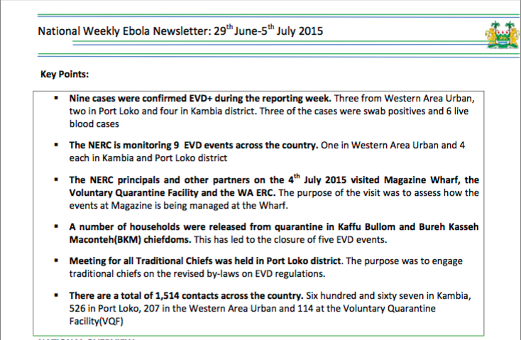
Figure 1: Portion of National Ebola Response Centre Weekly Newsletter
NERC also shared a daily evening briefing with the public (usually by radio), as well as a weekly newsletter and press conference.22 The public briefings included a wide variety of data on the current Ebola situation, including facts and figures on the status of the disease (often broken up by region), the location and accessibility of treatment centers, and other information on steps to address the crisis.23
Humanitarian Data Exchange (HDX)
On July 15, 2014, at the Open Knowledge Festival in Berlin, the United Nations Office for the Coordination of Humanitarian Affairs (OCHA) announced the development of the Humanitarian Data Exchange (HDX). HDX was intended as “a new data sharing platform that encompasses the best standards in data collection, offering access to useful and accurate data.”24 Designed to cover a wide range of humanitarian crises around the world, the platform was originally focused on two pilot locations in Kenya and Colombia. But as the Ebola crisis worsened, HDX’s potential in West Africa quickly became apparent and it became one of the most important data efforts in the fight against the epidemic.
HDX has been referred to as a “humanitarian data-centric Wikipedia.”25 It allows users to track and follow specific data sets, create curated organization data hubs, and share data across previously siloed organizations working to improve humanitarian efforts around the world. 26 According to Javier Teran, an OCHA statistician who works on HDX, the platform focused from the start on the “baseline indicators that humanitarians are always using, like population statistics and mortality rates – the types of data related to a crisis, before, during and after.”27 At its launch, HDX held around 1,600 files, covering a range of regions and humanitarian concerns – but none of those files were targeted to the use case that would take HDX from being a largely speculative platform to one being put to real practical application.28
By late 2014, Teran recalls, “we [the team behind HDX] were appointed by the UN to be the platform for Ebola data exchange.”29 At that point, the original 1,600 files on the platform were significantly increased in number, mostly with the addition of regional data – from Sierra Leone, Guinea and Liberia – drawn from WHO. WHO fed data into the platform on the number of Ebola cases and fatalities, the locations of cases, the amount of money being spent on the crisis, as well as information on Ebola Treatment Centres (ETCs – e.g., how many were open at the time, how many were eventually planned to be opened, and their locations).30 On-the-ground WHO representatives were tasked with collecting, validating and curating the information.31
As of January 2016, HDX held 178 data sets on the Sierra Leone location page, including information on the number of health-care workers infected; status and location of ETCs; status and location of safe and dignified burial teams; location of education establishments; status and location of Ebola Community Care Centers, and much more.32 The expected opening date for new ETCs was one of the most important pieces of information in HDX.33 This information was immediately made open in computable formats to analysts and developers working on Ebola response.
In order to collect all this information, the HDX team combined WHO situation report data with information pulled from existing data sources, like OpenStreetMap’s geospatial data and OCHA’s common operational data sets.34
A central task confronting the HDX team from the start was the need to “make connections with the different players in the field.”35 Teran notes that, “it was a very difficult assignment, especially at the beginning of the crisis,” due to a lack of sophistication in existing information systems. For example, it took some time for WHO representatives “to consolidate the information, to standardize it, to make it comparable” with information from other sources and other countries. This challenge, like Ebola itself, was not limited to Sierra Leone. “We were dealing with not only one country, but with three countries,” says Teran.36 This need to work across borders added a significant degree of complexity to the HDX effort, and indeed to the other data projects discussed in this case study.
As the HDX platform matured, visualizations, many created with platforms like Tableau and CartoDB, were also added. The top of the Ebola Crisis page featured a link to each of the most important data sets on the platform: Cumulative Cases of Ebola, Cumulative Deaths from Ebola, Response Plan Coverage, People Receiving Food Assistance, and Open Ebola Treatment Centers. Each of these could be viewed as raw data or as user-friendly visualizations. According to Teran, the statisticians leveraging HDX data were “trying to convert all these spreadsheets, CSVs, and maps into information” that was more easy to digest and understand.37 While the raw data was essential for policymakers and others fighting the disease, the visualizations played a particularly important role in disseminating information through intermediaries like the media.
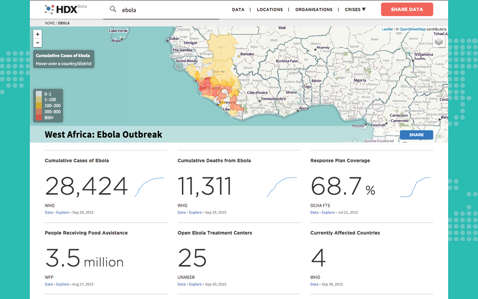
Figure 2: Humanitarian Data Exchange Ebola Crisis Page
The Ebola GeoNode
The result of a collaboration with the Red Cross, World Bank, Global Facility for Disaster Reduction and Recovery (GFDRR), UNMEER and the US Humanitarian Information Unit (HIU), Ebola GeoNode is an open source geospatial platform that lets users build maps and conduct geospatial analysis on Ebola’s impacts in West Africa. According to Patrick Dufour, a former senior Web GIS developer at HIU, Ebola GeoNode is primarily “an open data platform” designed with the intent “to make as much [data] as you can, open.”38
Currently, GeoNode consists of 61 data sets containing data on, among other things, administrative boundaries in affected countries, transportation and logistics information, and geo-tagged health crisis data. According to Dufour, logistics data – like the location of ETCs health facilities – occupy an especially important piece of the platform. While simple, such information helped to ensure that on-the-ground actors, like representatives of USAID and UNMEER, had a clear understanding of the location of important points – “sav[ing] a bunch of people time.”39
The GeoNode is more than a simple collection of points on a map, however. Information on the platform exists in three categories: Layers, Maps and Documents. In the Layers and Maps categories, users have the option of manipulating the information directly on the GeoNode website or downloading it for any other use. For example, when selecting the Sierra Leone Community Care Centres (CCC) layer, the user can download the geospatial data on the CCC’s locations to her hard drive in a variety of formats, or create a new map on GeoNode using the CCC data as one layer, with the option of adding additional layers – like the location of global supply routes.40 Similarly, the eight user-generated maps on the platform – Food Insecurity (Estimates), Health Facilities, Mali Admin Boundaries, Sierra Leone Admin Boundaries, Guinea Admin Boundaries, Liberia Admin Boundaries, and two Ebola Care Facilities maps41 – can be viewed, shared and printed as is, or duplicated and further built upon with additional geospatial data layers. The Documents category includes mapped trend analyses, such as “Evolution of confirmed Ebola cases over the period from 12 January to 22 February 2015.”42 These documents can be accessed directly, or the user can download the underlying metadata in a number of formats.
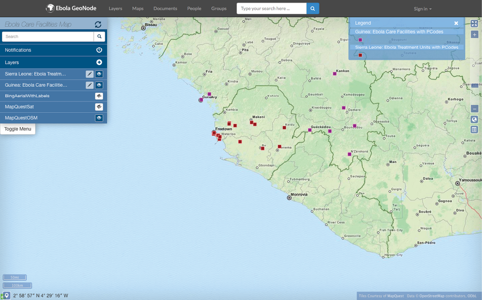
Figure 3: Ebola Care Facilities Map on Ebola GeoNode
The central purpose of the GeoNode platform was to alleviate information fragmentation that hampered the fight against Ebola. As the GFDRR website puts it: Data fragmentation meant that “field staff had to devote scarce time to finding and reassembling the data sets. In many cases, this task was far more difficult than it needed to be.”43 GeoNode played a particularly important role in enabling collaboration between employees working at international institutions and those on the ground in affected countries, particularly UNMEER representatives and employees of MapAction, a humanitarian mapping charity.44 Vivien Deparday, a disaster risk management specialist at GFDRR, points out that much of the work for those maintaining the GeoNode platform outside of West Africa was “providing technical support on the platform” for those on the ground and “maintaining some authoritative data sets” that could be used and supplemented by the UNMEER and MapAction representatives.45 Dufour agrees that the work of the people on the ground was critical for collecting and operationalizing the relevant data for the GeoNode – “otherwise, it’s just a bunch of people at headquarters talking to each other.”46
Read MoreReference
1 Special thanks to Akash Kapur who provided crucial editorial support for this case study, and to the peer reviewers [odimpact.org/about] who provided input on a pre-published draft.
2 Abdulai, Saffa. “Connecting Open Data and the Right to Information in Sierra Leone.” Open Data Research Network. http://www.opendataresearch.org/content/2014/642/connecting-open-data-and-right-information-sierra-leone
4 http://www.opengovpartnership.org/sites/default/files/SIERRA%20LEONE_FINAL%20NATIONAL%20ACTION%20PLAN_6_15_2014_Final.pdf
7 “Ebola virus disease – Fact Sheet.” World Health Organization. Updated January 2016. http://www.who.int/mediacentre/factsheets/fs103/en/
8 “Ebola (Ebola Virus Disease) – Signs and Symptoms.” Centers for Disease Control and Prevention. http://www.cdc.gov/vhf/ebola/symptoms/
9 “Ebola (Ebola Virus Disease) – Outbreaks.” Centers for Disease Control and Prevention. http://www.cdc.gov/vhf/ebola/outbreaks/
10 “Ebola (Ebola Virus Disease) – Outbreaks Chronology: Ebola Virus Disease.” Centers for Disease Control and Prevention. http://www.cdc.gov/vhf/ebola/outbreaks/history/chronology.html
11 Garrett, Laurie. “Ebola’s Lessons: How the WHO Mishandled the Crisis.” Foreign Affairs. September/October 2015. https://www.foreignaffairs.com/articles/west-africa/2015-08-18/ebolas-lessons
12 United Nations Security Council Resolution 2177 (2014). http://www.ifrc.org/docs/IDRL/UN%20SC%20Res.pdf
13 Spooner, Samantha. “Ebola could kill 100,000 and needs $1 billion to defeat, but Nigeria shows the world how it’s done.” Mail & Guardian Africa. September 21, 2014. http://mgafrica.com/article/2014-09-19-as-the-war-against-ebola-rages-nigeria-shows-the-world-how-its-done
14 Garrett, Laurie. “Ebola’s Lessons: How the WHO Mishandled the Crisis.” Foreign Affairs. September/October 2015. https://www.foreignaffairs.com/articles/west-africa/2015-08-18/ebolas-lessons
15 “UNMEER-WHO Transition Message.” World Health Organization Regional Office for Africa. http://www.afro.who.int/en/sierra-leone/press-materials/item/7897-unmeer-who-transition-message.html
16 Westcott, Lucy. “Q&A with Anthony Banbury: UN’s Ebola Mission Can Still Do More.” Newsweek. November 24, 2014. http://www.newsweek.com/qa-anthony-banbury-uns-ebola-mission-can-still-do-more-286724
17 Maxmen, Amy. “How Ebola Found Fertile Ground in Sierra Leone’s Chaotic Capital.” National Geographic. January 27, 2015. http://news.nationalgeographic.com/news/2015/01/150127-ebola-virus-outbreak-epidemic-sierra-leone-freetown-photos-pictures/
18 Maxmen, Amy. “How Ebola Found Fertile Ground in Sierra Leone’s Chaotic Capital.” National Geographic. January 27, 2015. http://news.nationalgeographic.com/news/2015/01/150127-ebola-virus-outbreak-epidemic-sierra-leone-freetown-photos-pictures/
19 Simons, Rupert. “Inside the National Ebola Response Centre.” Africa Governance Initiative. October 17, 2014. http://www.africagovernance.org/article/inside-national-ebola-response-centre
20 GovLab interview with Rupert Simons, Former Advisor to the African Governance Initiative; CEO Publish What You Fund, August 6, 2015.
21 Example brief: http://nerc.sl/sites/default/files/docs/20151126_Nerc_Eve_Brief%20Count%20Down.pptx%201.pdf
22 GovLab interview with Rupert Simons, Former Advisor to the African Governance Initiative; CEO Publish What You Fund, August 6, 2015.
23 Example newsletter: http://199.230.52.230/sites/default/files/docs/National%20%20Ebola%20Response%20%20Centre%20--%20Weekly%20%20%20Newsletter%20%2029th%20June%20-5th%20July%202015%20%282%29.pdf
24 “Humanitarian Data: OCHA launches ground-breaking data exchange platform.” United Nations Office for the Coordination of Humanitarian Affairs. July 15, 2014. http://www.unocha.org/top-stories/all-stories/humanitarian-data-ocha-launches-ground-breaking-data-exchange-platform
25 Griliopoulos, Dan. “Data exchange helps humanitarians act fast and effectively.” The Guardian. December 29, 2014. http://www.theguardian.com/global-development/2014/dec/29/humanitarian-data-exchange-ebola-refugees
26 Griliopoulos, Dan. “Data exchange helps humanitarians act fast and effectively.” The Guardian. December 29, 2014. http://www.theguardian.com/global-development/2014/dec/29/humanitarian-data-exchange-ebola-refugees
27 GovLab interview with Javier Teran, Statistician, United Nations Office for the Coordination of Humanitarian Affairs, Humanitarian Data Exchange, September 18, 2015.
28 GovLab interview with Javier Teran, Statistician, United Nations Office for the Coordination of Humanitarian Affairs, Humanitarian Data Exchange, September 18, 2015.
29 GovLab interview with Javier Teran, Statistician, United Nations Office for the Coordination of Humanitarian Affairs, Humanitarian Data Exchange, September 18, 2015.
30 GovLab interview with Javier Teran, Statistician, United Nations Office for the Coordination of Humanitarian Affairs, Humanitarian Data Exchange, September 18, 2015.
31 GovLab interview with Javier Teran, Statistician, United Nations Office for the Coordination of Humanitarian Affairs, Humanitarian Data Exchange, September 18, 2015.
33 GovLab interview with Javier Teran, Statistician, United Nations Office for the Coordination of Humanitarian Affairs, Humanitarian Data Exchange, September 18, 2015.
34 GovLab interview with Javier Teran, Statistician, United Nations Office for the Coordination of Humanitarian Affairs, Humanitarian Data Exchange, September 18, 2015.
35 GovLab interview with Javier Teran, Statistician, United Nations Office for the Coordination of Humanitarian Affairs, Humanitarian Data Exchange, September 18, 2015.
36 GovLab interview with Javier Teran, Statistician, United Nations Office for the Coordination of Humanitarian Affairs, Humanitarian Data Exchange, September 18, 2015.
37 GovLab interview with Javier Teran, Statistician, United Nations Office for the Coordination of Humanitarian Affairs, Humanitarian Data Exchange, September 18, 2015.
38 GovLab interview with Patrick Dufour, Former Senior Web GIS Developer, U.S. Department of State, Humanitarian Information Unit, December 17, 2015.
39 GovLab interview with Patrick Dufour, Former Senior Web GIS Developer, U.S. Department of State, Humanitarian Information Unit, December 17, 2015.
41 http://ebolageonode.org/maps/#?limit=100&offset=0
45 GovLab interview with Vivien Deparday, Disaster Risk Management Specialist, Open Data for Resilience Initiative Operational Deployment Lead, Global Facility for Disaster Risk and Reduction, World Bank, December 17, 2015.
46 GovLab interview with Vivien Deparday, Disaster Risk Management Specialist, Open Data for Resilience Initiative Operational Deployment Lead, Global Facility for Disaster Risk and Reduction, World Bank, December 17, 2015.
47 GovLab interview with Rupert Simons, Former Advisor to the African Governance Initiative; CEO Publish What You Fund, August 6, 2015.
48 GovLab interview with Javier Teran, Statistician, United Nations Office for the Coordination of Humanitarian Affairs, Humanitarian Data Exchange, September 18, 2015.
49 GovLab interview with Rupert Simons, Former Advisor to the African Governance Initiative; CEO Publish What You Fund, August 6, 2015.
50 Simons, Rupert. “Inside the National Ebola Response Centre.” Africa Governance Initiative. October 17, 2014. http://www.africagovernance.org/article/inside-national-ebola-response-centre
51 GovLab interview with Patrick Dufour, Former Senior Web GIS Developer, U.S. Department of State, Humanitarian Information Unit, December 17, 2015.
52 Cassano, Jay. “Inside the Crowdsourced Map Project That Is Helping Contain the Ebola Epidemic.” Fast Company. October 22, 2014. http://www.fastcolabs.com/3037350/elasticity/inside-the-crowdsourced-map-project-that-is-helping-contain-the-ebola-epidemic
53 GovLab interview with Rupert Simons, Former Advisor to the African Governance Initiative; CEO Publish What You Fund, August 6, 2015.
54 GovLab interview with Patrick Dufour, Former Senior Web GIS Developer, U.S. Department of State, Humanitarian Information Unit, December 17, 2015.
55 GovLab interview with Javier Teran, Statistician, United Nations Office for the Coordination of Humanitarian Affairs, Humanitarian Data Exchange, September 18, 2015.
56 GovLab interview with Patrick Dufour, Former Senior Web GIS Developer, U.S. Department of State, Humanitarian Information Unit, December 17, 2015.
57 GovLab interview with Vivien Deparday, Disaster Risk Management Specialist, Open Data for Resilience Initiative Operational Deployment Lead, Global Facility for Disaster Risk and Reduction, World Bank, December 17, 2015.
58 GovLab interview with Patrick Dufour, Former Senior Web GIS Developer, U.S. Department of State, Humanitarian Information Unit, December 17, 2015.
59 GovLab interview with Javier Teran, Statistician, United Nations Office for the Coordination of Humanitarian Affairs, Humanitarian Data Exchange, September 18, 2015.
60 GovLab interview with Patrick Dufour, Former Senior Web GIS Developer, U.S. Department of State, Humanitarian Information Unit, December 17, 2015.
61 GovLab interview with Javier Teran, Statistician, United Nations Office for the Coordination of Humanitarian Affairs, Humanitarian Data Exchange, September 18, 2015.
62 GovLab interview with Javier Teran, Statistician, United Nations Office for the Coordination of Humanitarian Affairs, Humanitarian Data Exchange, September 18, 2015.
63 GovLab interview with Javier Teran, Statistician, United Nations Office for the Coordination of Humanitarian Affairs, Humanitarian Data Exchange, September 18, 2015.
64 GovLab interview with Rupert Simons, Former Advisor to the African Governance Initiative; CEO Publish What You Fund, August 6, 2015.
65 GovLab interview with Rupert Simons, Former Advisor to the African Governance Initiative; CEO Publish What You Fund, August 6, 2015.
66 GovLab interview with Javier Teran, Statistician, United Nations Office for the Coordination of Humanitarian Affairs, Humanitarian Data Exchange, September 18, 2015.
67 GovLab interview with Javier Teran, Statistician, United Nations Office for the Coordination of Humanitarian Affairs, Humanitarian Data Exchange, September 18, 2015.
68 GovLab interview with Patrick Dufour, Former Senior Web GIS Developer, U.S. Department of State, Humanitarian Information Unit, December 17, 2015.
69 GovLab interview with Patrick Dufour, Former Senior Web GIS Developer, U.S. Department of State, Humanitarian Information Unit, December 17, 2015.
70 GovLab interview with Vivien Deparday, Disaster Risk Management Specialist, Open Data for Resilience Initiative Operational Deployment Lead, Global Facility for Disaster Risk and Reduction, World Bank, December 17, 2015.
71 “Report of the Ebola Interim Assessment Panel.” World Health Organization. May 2015. http://www.who.int/entity/csr/resources/publications/ebola/report-by-panel.pdf?ua=1
72 GovLab interview with Javier Teran, Statistician, United Nations Office for the Coordination of Humanitarian Affairs, Humanitarian Data Exchange, September 18, 2015.
73 GovLab interview with Javier Teran, Statistician, United Nations Office for the Coordination of Humanitarian Affairs, Humanitarian Data Exchange, September 18, 2015.
75 GovLab interview with Javier Teran, Statistician, United Nations Office for the Coordination of Humanitarian Affairs, Humanitarian Data Exchange, September 18, 2015.
76 GovLab interview with Javier Teran, Statistician, United Nations Office for the Coordination of Humanitarian Affairs, Humanitarian Data Exchange, September 18, 2015.
77 GovLab interview with Vivien Deparday, Disaster Risk Management Specialist, Open Data for Resilience Initiative Operational Deployment Lead, Global Facility for Disaster Risk and Reduction, World Bank, December 17, 2015.
78 GovLab interview with Vivien Deparday, Disaster Risk Management Specialist, Open Data for Resilience Initiative Operational Deployment Lead, Global Facility for Disaster Risk and Reduction, World Bank, December 17, 2015.
79 GovLab interview with Vivien Deparday, Disaster Risk Management Specialist, Open Data for Resilience Initiative Operational Deployment Lead, Global Facility for Disaster Risk and Reduction, World Bank, December 17, 2015.
80 Quinn, Kristin. “An Unprecedented Response: The GEOINT Community’s Role in the Ebola Relief Effort.” Trajectory Magazine. 2015. http://trajectorymagazine.com/government/item/1908-an-unprecedented-response.html
81 GovLab interview with Vivien Deparday, Disaster Risk Management Specialist, Open Data for Resilience Initiative Operational Deployment Lead, Global Facility for Disaster Risk and Reduction, World Bank, December 17, 2015.
82 O’Carroll, Lisa and Umaru Fofana. “WHO officially declares Sierra Leone Ebola-free.” The Guardian. November 7, 2015. http://www.theguardian.com/world/2015/nov/07/world-health-organisation-sierra-leone-ebola-free
83 “Sierra Leone dissolves Ebola response centre.” The Citizen. January 6, 2016. http://www.thecitizen.co.tz/News/Sierra-Leone-dissolves-Ebola-response-center/-/1840340/3022944/-/11h8g99z/-/index.html
84 “Sierra Leone dissolves Ebola response centre.” The Citizen. January 6, 2016. http://www.thecitizen.co.tz/News/Sierra-Leone-dissolves-Ebola-response-center/-/1840340/3022944/-/11h8g99z/-/index.html
85 “Sierra Leone dissolves Ebola response centre.” The Citizen. January 6, 2016. http://www.thecitizen.co.tz/News/Sierra-Leone-dissolves-Ebola-response-center/-/1840340/3022944/-/11h8g99z/-/index.html
86 Searcey, Dionne and Sheri Fink. “Day After a Victory Over Ebola, Sierra Leone Reports a Death.” The New York Times. January 15, 2016.